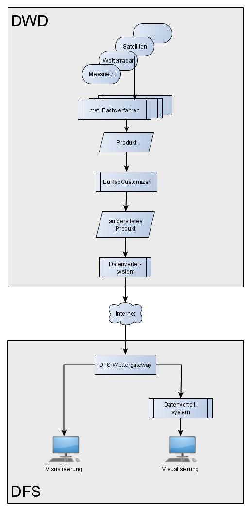
Germany’s National Meteorological Service (Deutscher Wetterdienst, DWD) provides DFS Deutsche Flugsicherung GmbH (DFS) with aeronautical meteorological information, which is further processed in the DFS systems or displayed either directly in the monitor of the controller working position or in visualisation systems arranged in parallel. The objective of the joint project WxVis4ATC (Weather Visualisation for Air Traffic Control [ATC]), which was funded by the German Federal Ministry of Economics as part of the Federal Aviation Research Programme, was an interpretation-free, process-oriented and ergonomic visualisation of a selection of aeronautical meteorological information in the technical systems of the DFS. The main objective of the MeteoSolutions GmbH in this joint project was the development of software for a specialised processing of the aeronautical meteorological information provided by the DWD. This involved, on the one hand, technical processing (e.g. with regard to the required geographic projection, spatial resolution, etc.) and, on the other hand, conversion into defined, standardised data formats (ASTERIX Cat 009, HDF5). As a result, the software EuRadCustomizer of the MeteoSolutions GmbH was extended by the new part developed in the joint project after its completion.
An essential aspect of this software is that the meteorological information is not modified by the processing (e.g. there is a wrong spatial reference). For this purpose, additional software was created to generate a generic, synthetic test product that can be used to test the entire process chain from the preparation of the aeronautical meteorological information and the provision of data to the processing and visualisation in the DFS systems. Such software represents essential quality assurance, especially in a particularly safety-relevant environment such as air traffic control.
Furthermore, a definition for so-called "Adverse Wx Zones" (AWxZ) from another project was reviewed in this joint project by MeteoSolutions GmbH. AWxZs are areas that should not be flown through by commercial aircraft due to weather conditions (e.g. during heavy thunderstorms). The present definition, based on the study of the flight behaviour of commercial aircraft during adverse weather conditions, was confirmed. It also uses aeronautical meteorological information from the DWD and could thus be integrated into the specialised software for processing this information for the systems of DFS.